
QUARTERLY REPORT April – June 2003
Quarterly Report April – June 2003
Highlights
- The Bendigo Mining Board of Directors has concluded that:
- Further sampling and exploration studies, other than those required for delineation of Resources and Reserves, will not significantly improve the current accuracy of grade determination, and • Commercial production should commence without delay.
- To this end • Design of a 300,000 tonne per annum plant has commenced,
- The necessary permits are being sought,
- A feasibility study should be completed by year-end,
- Funding options for the project will be studied, and
- Production of gold should commence in early 2005.
- Probable Reserves delineated to date: 440,000 tonnes in a grade range of 7.5 to 9.5 g/t gold (best estimate 8.5 g/t) for 120,000 oz Au.
- The Company estimates the Reserves will be 200,000 oz Au by December 2003.
- Significantly higher grades being discovered in the Lower S3 Garrard Reef, where 50kg ore samples consistently assaying at more than 30 g/t gold over the 80 metres accessed to date. The total drill indicated strike length is 450 metres.
Milestones
- October – December 2003
- Complete definition of 200,000 oz Au Probable Reserve.
- Complete feasibility study to support a decision to commence construction of commercial-sized mine facilities for production.
- January – March 2005
- First gold pour from Stage One Production.
Reserves and Resources
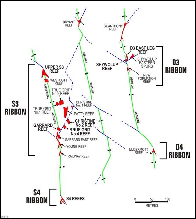
The New Bendigo project was initiated by Bendigo Mining based on the insight that the gold reefs at Bendigo occur in sub-horizontal “ribbons” that repeat at predictable vertical intervals. Detailed historical studies on 5 of the 15 major lines of reef (anticlines) identified a resource potential of at least 12 million oz Au beneath the historic workings.
Subsequent diamond drilling enabled the announcement in July 2001 of an Inferred Resource of 1.8Mt with an estimated in-situ grade range of 10 -15 g/t Au (best estimate 12 g/t Au) for 700,000 oz Au. The Inferred Resource is located within 17 separate bodies of gold mineralised quartz reefs and stockwork zones within three ribbons designated S3, D3 and D4 at the southern end of the field. The historical data suggest that the ribbons in this area are likely to be of lower grade than the average grade of the field.
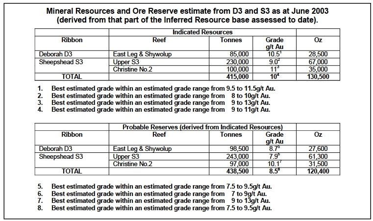
Infill drilling and bulk sampling within 4 of the 17 bodies in the S3, D3 and D4 ribbons enabled the following interim Mineral Resource and Ore Reserve estimate.
The area tested is estimated to contain an Indicated Resource of 415,000 tonnes with a best estimate in-situ grade of 10 g/t Au (within an estimated grade range of 9 to 11 g/t Au) containing 130,000 oz Au. A Probable Reserve of 440,000t with a best estimate grade of 8.5 g/t Au (within an estimated grade range of 7.5 to 9.5 g/t Au) containing 120,000 oz Au was derived from the Indicated Resource estimate. The Reserve estimate allows for dilution of grade and for losses.
Bendigo’s targeted Reserve base to support Stage 1 production is 200,000 oz Au. The Company is on track to achieve the target by December 2003.
The Bendigo Field with its coarse nuggety gold presents some unique challenges in resource and reserve estimation, and appended to this report is a summary on the assigning of grade to resources at Bendigo.
Inferred Resources
A statement of the Inferred Resource base will be included in the 2003 Annual Report.
D3 Reserve Estimate
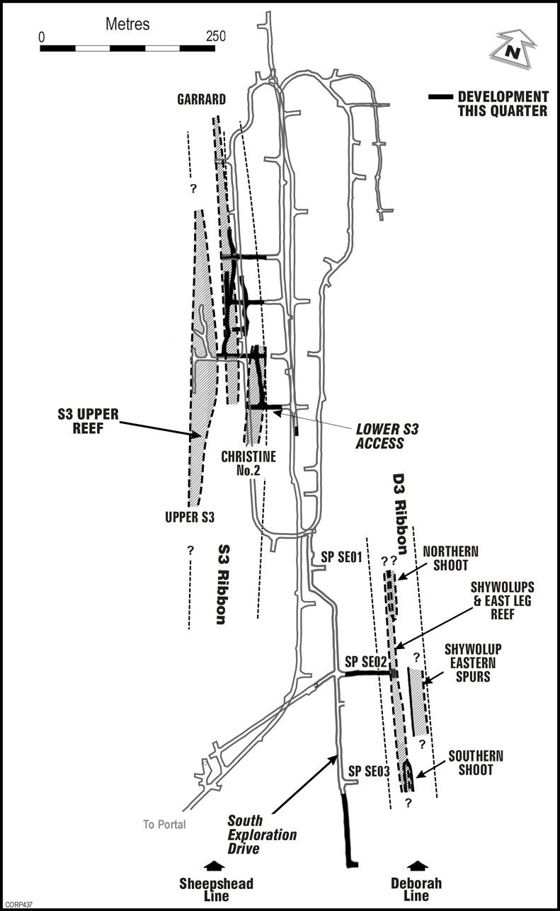
The Reserve estimate in the D3 ribbon is within the D3 East Leg and Shywolup reefs. A total of 155 drill holes, for some 512 metres of drill intersections and 268 metres of on-reef development were completed in the testing of the reefs. 12 bulk samples and 184 x 50kg samples (usually 2 samples from each development round) were collected from within the resources.
The gold mineralisation in the D3 East Leg occurs as two, relatively small, high grade shoots (approximately 30g/t Au) within a narrow, bedding parallel, laminated vein. The two bulk samples collected from within the East Leg resources averaged 53g/t Au. The majority of the identified resource occurs within Shywolup reef, which has a total drill indicated strike length of 350 metres and an estimated grade of 9g/t Au. Ten bulk samples were collected from within the Shywolup resource and they averaged 10g/t Au.
Mineralisation within both reefs continues to the south beyond the current limit of drilling.
S3 Reserve Estimate
The Reserve estimate for S3 is within only two reefs, the Upper S3 and Christine No. 2.
The Upper S3 reef has been drill tested by 551 metres of diamond drilling in 64 drill intersections, as well as 175 metres of on-reef development from which 13 bulk samples and 116 x 50kg samples were collected and assayed. The bulk samples averaged 10.5g/t Au. The resource has been defined over a strike length of 450 metres and the reef remains open to the north and south.
The 85 metres of on-reef development completed to date in Christine No. 2 Reef straddle the lower boundary of the resource and as a result the nine bulk samples collected are unrepresentative, as they contain a high percentage of dilution. Consequently the resource grade was estimated from the drill indicated grade. This reliance on drilling data to estimate grade is reflected in the larger estimated grade range. The reef has been drill tested over a strike length of 150 metres and is open to the south.
Mid and Lower S3 Reefs Exploration
The exploration of the Mid S3 reefs during the quarter has shown them to be structurally complex and potentially of lower grade than originally estimated. On the other hand, the shapes of the higher-grade reefs in Lower S3 are simpler and larger than originally estimated.
Access has been gained into the Lower S3 reefs from the Swan Decline. Some 85 metres of development has been completed along the lower boundary of Christine No.2 Reef, from which detailed drill testing of the overlying reef has been conducted. Vertical development for bulk sampling into the reef is planned in the coming months.
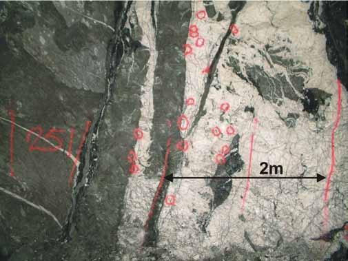
On-reef development has commenced on Garrard Reef with a substantial portion of the reef that has been exposed to date containing abundant visible gold. Preliminary 50kg sample results for the latest 80 metres of on-reef development indicate grades consistently in excess of 30g/t Au over the full width of development (4 metres). The total drill indicated strike length is 450 metres.
S4 Ribbon
During the quarter, 4 holes were drilled over an 80 metre vertical section into the S4 ribbon. Both drill sections intersected extensive quartz veining containing arsenopyrite and minor visible gold.
Preparation for Production
While the main focus of Bendigo’s work to date has been on exploration and the methodology of determination of Resources and Reserves, the Company has undertaken initial studies for Stage One production of around 300,000 tonnes per annum.
Having established greater confidence in its ability to determine Reserves, the Company is now proceeding on a feasibility study for Stage One Production, addressing areas which include:
- Mine planning, dewatering, ventilation requirements and secondary egress;
- Metallurgical testwork and design of the process flow-sheet for the recovery of gold;
- Other surface infrastructure requirements, including the treatment and disposal of water, tailings and mullock;
- Obtaining necessary additional permits.
The Company expects to complete this planning in the December Quarter 2003, with full additional permitting achieved in the June Quarter 2004, for targeted initial production in the March Quarter 2005.
In this document, the term “resource potential” is used to describe the Company’s estimate of the contained ounces of gold which it believes, on the basis of a technical evaluation of available data and geological extrapolation, should occur within the New Bendigo. It is emphasised that this term is not covered by the JORC Code and is not equivalent to a Mineral Resource or Ore Reserve estimate.
The information in this report that relates to Mineral Resources or Ore Reserves is based on, and accurately reflects, information compiled by G F Johansen, Member of the Australian Institute of Mining and Metallurgy. Mr Johansen is a full-time employee of the Company and has relevant experience in relation to the mineralisation being reported to qualify as a Competent Person as defined in the Australian Code for Reporting of Mineral Resources and Ore Reserves. Mr Johansen consents to the inclusion in the report of the matters based on the information in the form and context in which it appears
APPENDIX TO JUNE 2003 QUARTERLY REPORT
Assigning Grade to Gold Reserves and Resources at Bendigo
The gold in the Bendigo reefs is present as coarse particles, which are erratically distributed. This coarse nature results in the high “nugget effect”.
The combination of the erratic gold distribution and high nugget effect makes traditional drill- sampling and assaying methods ineffective in accurately defining the gold content within a reef.
Historically, for more than 100 years, miners were able to determine grade boundaries successfully with virtually no reliance on assays. Grade boundaries were determined visually through the identification of visible gold, associated minerals and the general look of the quartz, with some assay support from dollying, occasional bulk sampling and by using production itself as a form of continuous bulk sample.
During the ten years that the Company has been redeveloping the goldfield, a very substantial database of assays has been assembled. These data have confirmed the strong correlation between the identification of coarse visible gold and grade.
The Company’s systematic sampling program includes drill-core assays, development face rock- chip samples, 50kg samples from on-reef development, selective bulk samples of development ore (80 to 200 tonnes) and some trial ore parcels (1,000 to 5,000 tonnes). Larger samples provide a significantly better indication of actual grade than small samples.
The exact method of generating a best estimate grade will vary from reef to reef depending on the information available.
Bendigo Mining is developing a system of estimating the grade of individual drill intersections not just by averaging assay data numerically, but by taking into account the local geological characteristics and making a technical assessment of the significance of gold abundance. The outcome is a technically valid “assigned grade” for each drill intersection, which eventually will be used to determine the grade in resource estimations. As more data from development and production become available, and correlation factors are determined, the technical integrity of this “assigned grade” methodology will become increasingly reliable.